Published: 23 Sep 2026
As surveyors, we look at landscapes and their features from all kinds of perspectives – at ground level, below ground level and even underwater. But perhaps the most expansive and impressive overview is a bird’s eye view of landscapes from the sky. The vast wealth of information that can be gathered by aerial view can cover huge areas of inaccessible topography in a comparatively short space of time. So, in this web article, we take to the sky and ask: “Where would we be without Aerial LiDAR Surveys?”
Pilot schemes
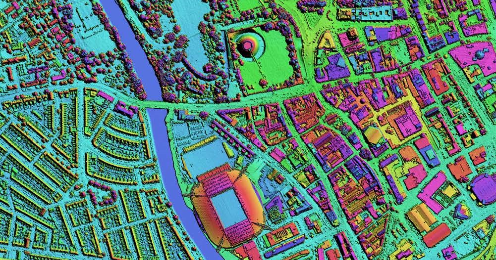
Aerial LiDAR (Light Detection and Ranging) Surveys can provide a fast and reliable airborne method of collecting three-dimensional data, when correctly planned, controlled and checked. This data can then be used to create Digital Surface Models. A LiDAR system uses a sensor that projects laser pulses to measure distances to features and the ground. Where a digital camera is included, colour images can supplement the LiDAR data to help interpret visible ground and surface features.
Aerial LiDAR can capture highly detailed point cloud data. This information can then be processed to produce Digital Surface and Terrain Models and support other mapping products. It can record tree canopies and the ground beneath where laser pulses reach the ground through gaps in vegetation. It does not see through solid foliage, and dense vegetation can leave gaps in ground coverage.
Developments in uncrewed aerial vehicles (UAVs), commonly called drones, have increased the range of survey platforms available. Piloted aircraft and UAVs can both produce high-quality data; neither is inherently more accurate. Sensor capability, flight planning, positioning, calibration and independent checks determine whether the required accuracy is achieved.
When it comes to geospatial surveying technology, it’s important not to lose sight of a surveyor’s skills and professional expertise. You can have state-of-the-art kit, but equipment alone cannot demonstrate that the results meet the required accuracy or intended use. Professional geospatial surveyors specify, control, verify and explain the data, including its limitations.
The sky’s the limit
In a typical pulsed aerial LiDAR system, a laser emits light pulses towards the ground. When a pulse encounters a surface, some of the light is reflected back to the sensor. The distance to that surface is calculated using the speed of light in air and the time taken for the pulse to travel there and back, divided by two.
The laser measures distance, not height on its own. Global Navigation Satellite Systems (GNSS) and an inertial measurement unit (IMU) provide the sensor’s position and orientation, including pitch, roll and heading. Combining these with laser ranges, scan angles, precise timing and calibration allows three-dimensional point coordinates to be calculated. The results are then related to the specified coordinate system and height datum, and checked against independent survey measurements.
Accuracy that can be demonstrated
Modern airborne LiDAR systems can collect large volumes of measurements rapidly. Piloted aircraft are well suited to extensive coverage, while UAVs can support more localised surveys. The right approach depends on the required detail, accuracy, site conditions and safe operating arrangements. This surveying method is particularly useful across areas which may be hostile or inaccessible from the ground, such as forested areas or mountainous regions. LiDAR can reveal subtle ground features where sufficient valid returns are obtained, but high point density alone does not prove accuracy. Airborne capture can reduce exposure to ground-based hazards, but flight planning, appropriate permissions, site-specific risk assessment and compliance with the equipment’s laser safety requirements remain essential.
An eye in the sky
LiDAR supports a wide range of geospatial applications and is an important part of a surveyor’s toolkit.
These surveys can be used in industries and disciplines including urban planning, vegetation modelling, change detection, proximity modelling, floodplain mapping, stockpile monitoring, road and rail infrastructure planning, coastal erosion monitoring, archaeological landscape recording and the generation of vector mapping for engineering applications.
Without aerial LiDAR, mapping many of these expanses would be slower or less practical using ground-based methods alone. These surveys provide a surveyor’s eye in the sky. For design or engineering work, a surveyor may also combine aerial LiDAR with photogrammetry, ground-based measurements or other techniques to complete and verify the required information.
GSA members provide specialist survey services across a diverse range of projects. Engaging a professional geospatial surveyor can reduce project risk, improve efficiency, and ensure your survey data is suitable for its intended purpose.
To help you specify and procure survey services with confidence, download our client guides for practical advice on survey techniques, tendering, and choosing the right supplier.
The Geospatial Survey Association also offers a range of guidance notes covering many aspects of surveying. View and download all guides here, including Client Guide – Aerial LiDAR Surveys https://www.gsa-uk.org.uk/resources/downloads/